Welcome to the SoilCare Interactive Mapping Tool!
The SoilCare IMT shows the potential of various Soil Improving Cropping Systems (SICS) across Europe using interactive maps. The maps are complemented with a description of the SICS and additional application and adoption factors that are less suitable to be mapped.
The potential to apply SICS across Europe is split into various components:
The SoilCare IMT allows to explore maps that have been produced for each of the above components, as well as for the combined applicability and relevance maps (Combined Applicability/Relevance) and a combination of all three components into the SICS Potential Index. More information on the SICS Potential Index can be found here.
The SoilCare IMT allows to compare maps. For each map window a selection can be made on factors included in the analysis:
In addition, a selection is made for each window as to what map will be shown:
For the range of SICS that were investigated in the SoilCare study sites, applicability, relevance, and combined applicability/relevance maps are available. For a selection of SICS (cover crops, mulching, minimum tillage, and compaction alleviation) impacts and the SICS Potential Index can be selected.
More information on the SoilCare IMT, including example applications are available in deliverable D6.3 Interactive mapping tool for the application of soil-improving CS across Europe.
The figure below illustrates how the (A) applicability, (B) relevance and (C) impact maps and the SICS Potential Index were created.
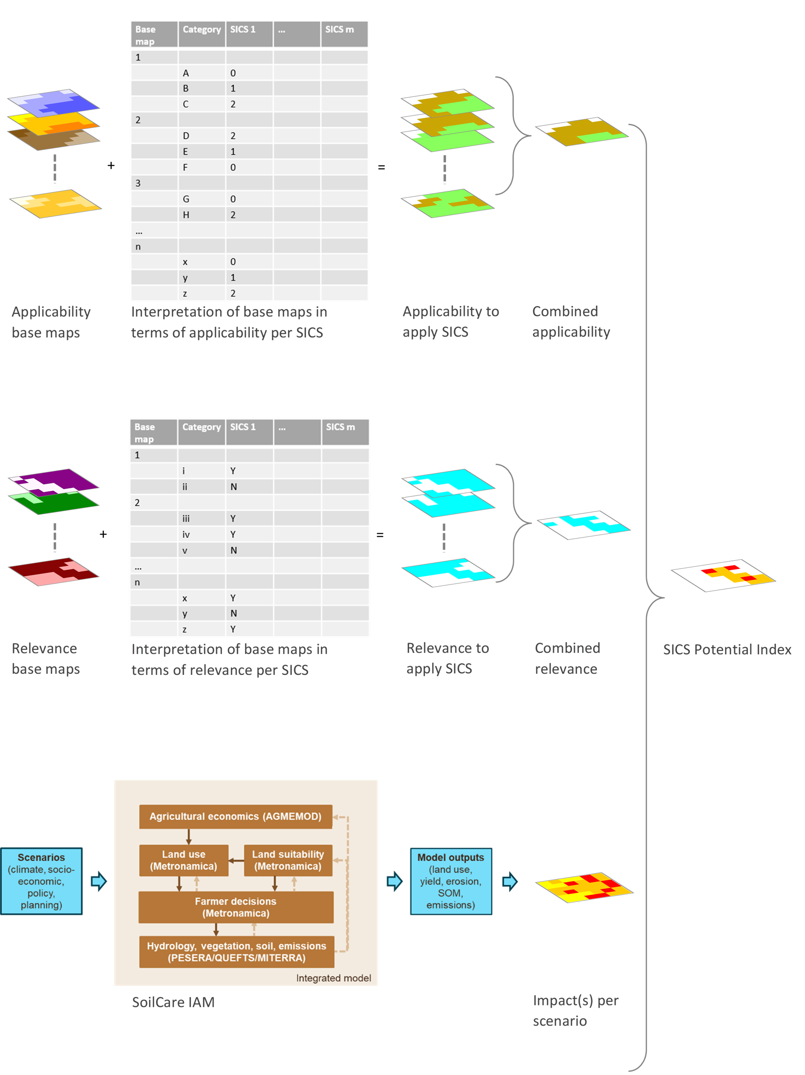
Components A and B are developed using a combination of European-wide maps - the Applicability base maps (characteristics of climate, soil, and land use) and the Relevance base maps (occurrence of degradation processes or soil quality aspects) - and expert judgement. More information on the maps and related data sources is provided in the SoilCare Report on upscaling of field trial results (Deliverable 6.1).
Rankings derived from the expert judgement are extracted in a spreadsheet. These are used to create maps for the Applicability to implement the SICS (with classes 'applicable' (2), 'not preferred' (1) and 'not applicable' (0)) and the Relevance to apply the SICS (with classes 'relevant' (1) and 'not relevant'). The set of Applicability to apply the SICS maps is merged into a Combined applicability map by taking the minimum value across these maps implying that a restriction in any of the base maps limits the application of the SICS at that location. The Relevance to apply the SICS maps are combined into the Combined relevance map by taking the maximum value across the maps, indicating that a location is relevant for applying the SICS if it is relevant for at least one of the relevance factors at that location.
For component C, calculating the impact of applying a SICS, we make use of the SoilCare Integrated Assessment Model (IAM), developed as part of the SoilCare project. This model is applied to Europe at a 100-500 m. resolution and includes land use, land management and biophysical components of agricultural production. For selected SICS (cover crops, mulching, minimum tillage, and compaction alleviation) the impact is calculated on soil organic carbon (SOC), water erosion (sustainability indicators) and crop yield (profitability indicator). For each indicator, result maps from the SoilCare IAM are classified into low (1), medium (2) and high (3) impact. More information on the SoilCare IAM can be found in the SoilCare Report on the potential for applying SICS across Europe (Deliverable 6.2).
Using the A (applicability), B (relevance) and C (impact) maps, we subsequently calculate a SICS Potential per Indicator type. The overall SICS Potential Index is constructed by combining the applicability, relevance and (combined set of) impact maps for each SICS. Details can be found in the SoilCare Report on upscaling of field trial results (Deliverable 6.1).
Because not all application and adoption factors can be provided in maps, a descriptive summary on these topics is provided for each SICS.
The SoilCare Interactive Mapping Tool (IMT) was developed as part of the EU funded H2020 project: Soil Care for profitable and sustainable crop production in Europe (H2020-SFS-2015-2b, grant agreement 677407).
An introduction to the tool is provided in deliverable D6.3 of the project:
D6.3 Interactive mapping tool for the application of soil-improving CS across Europe
More details of the methodology can be found in deliverable D6.1 of the project:
D6.1 Report on the integration and synthesis of Study Site results and their potential for upscaling
Data currently included in the webtool was created as part of D6.1 (created November 2021) and is therefore in line with D6.1.
For more information about the SoilCare IMT, please contact:
WP6 leader: Hedwig van Delden (hvdelden@riks.nl)
Project coordinator: Rudi Hessel (rudi.hessel@wur.nl)
More information about SoilCare can be found on the project website: https://www.soilcare-project.eu/.

This project is financed by the H2020 program EU Grant Agreement ID: 677407
©2021 the SoilCare project and Partners